(Page 2 of 2)
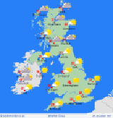 Mainly dry with sunny spells. Good morning, A fine start with sunshine
for many, though northwest Scotland and parts of East Anglia will
see thicker cloud and patchy drizzle. Cloud will build across northern
and central England through the day, bringing a slight chance of drizzle,
but most places will stay dry. Northern Scotland will remain cloudier
with some light rain, while elsewhere it will be dry with sunny spells.
Evening showers across northern England will fade, leaving a largely
dry night. Clear spells are expected across Wales and southern England,
while northern areas stay cloudier. Northern and eastern Scotland
will see light rain or drizzle, with longer spells of rain possible
in the northwest. Warmest again in southern and western areas. Highs
at 18C to 23C across Scotland into northern England as well as Ireland.
24C to 28C across Wales and southern England. Have a great day. Alexi
Mainly dry with sunny spells. Good morning, A fine start with sunshine
for many, though northwest Scotland and parts of East Anglia will
see thicker cloud and patchy drizzle. Cloud will build across northern
and central England through the day, bringing a slight chance of drizzle,
but most places will stay dry. Northern Scotland will remain cloudier
with some light rain, while elsewhere it will be dry with sunny spells.
Evening showers across northern England will fade, leaving a largely
dry night. Clear spells are expected across Wales and southern England,
while northern areas stay cloudier. Northern and eastern Scotland
will see light rain or drizzle, with longer spells of rain possible
in the northwest. Warmest again in southern and western areas. Highs
at 18C to 23C across Scotland into northern England as well as Ireland.
24C to 28C across Wales and southern England. Have a great day. Alexi
------
back...
Main Menu
-----